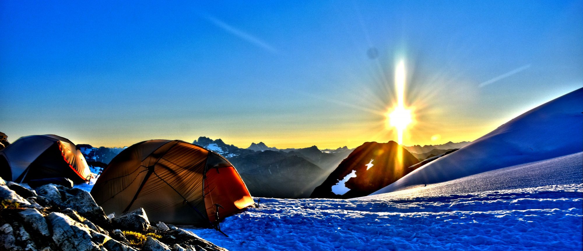
Woke up at 1:00am, it was silent as the wind had stopped. It was very peaceful but cold, 34 degrees inside my tent to be exact. I woke up again at 5:45am to Brien telling me I need to look outside. I unzipped my tent and stuck my head out and saw the most stunning sunrise I have every witnessed. I quickly took out my camera and started taking photos. I even got out of my tent not fully dressed and kept taking photos of all directions. The cold did not bother me one bit.

Started packing up around 7:15am and hoping the weather holds out so we can get to Cub Lake. It will be a long day. Even though we are one day behind cause of the storm, I am not worried at all. I told family and friends that I was expected back on Friday, but not to worry unless they don’t hear anything by Sunday night, and even then to not worry. That gives me two full days if anything went wrong to fix it myself. We were off and said goodbye to the two climbers. It was nice to leave early and walk on crunchy snow. Crampons had better grip that way. We are about to cross South Cascade Glacier which I was told was the deepest glacier in the lower 48. I haven’t verified this but as soon as I saw it, I believe it. It’s massive! We crossed South Cascade Glacier and I sure felt small walking on it. I felt like I was walking across Antarctica and the only thing missing was the penguins.

South Cascade Glacier
We arrived at the top of the pass after an easy glacier crossing and the views keep getting better! Looking down on White Rock Lakes I was surprised to see some of the bluest water I have ever seen in my life. Lakes were partially frozen over and then the view of Dana Glacier in the background, just beautiful. We carefully worked our way down the steep snow until we hit the first lake and walked around to a snow free place between both lakes where we had lunch and figure out what to do next.

White Rock Lakes
Dana Glacier is not what we expected. We checked the map multiple times to make sure that was were we were supposed to go next, yep, that’t it. There is no way we can safely do that without rope. The steep face of that mountain of all snow looking right at us was not what we were expecting. Everything we read showed it was very steep at times and a lot of rock ribs to get through. With rope and climbing gear, it can be done, heck it can be done without rope of course but I wasn’t willing to bet my life on it. The only exit that has been talked about was going East along the West Fork of Agnes Creek through very heavy bush wacking until you hit the Pacific Crest Trail which was 10-13 miles away. Now once you reach Cub Lake, you have to bushwack anyways to get out to the Suiattle River road. So we had some thinking to do.

Dana Glacier
After looking at maps, we decided to maybe try something that maybe no one has ever done being it was never talked about in anything we have seen or even offered as an alternate to get to the Suiattle River road. We would go Southwest up the snow over a ridge and drop down into a valley and follow the creek until we found a small trail that took us right into the Suiattle River road and come out at the exact same spot we would of came out at if we went to Cub Lake.
We started around the lake and working our way up to the pass. It started off nice but quickly and got steep and a little iffy, but it had to be way safer then trying Dana Glacier. As I neared the top my hiking poles went straight through the snow a couple times and really had to take it slow and careful. Once at the top, we could look a ways through the valley, but not as far as before. We are lower then we have been this whole trip and the tree line is not far away now. Now was the time to figure out how we would get down from up here, this hasn’t been done before as far as we know and no information about it. Going to the right looks nice, but there is a waterfall and cliff face which didn’t allow us to go that way, and to the left was nearly a vertical cliff as well. so we zig zaged our way down carefully and managed to get to the creek and before we knew it, we were walking through a meadow by the creek and into the trees again!

Brien scanning terrain
Brien mentioned that we should probably start to keep our eyes out for bears and other wildlife, and as soon as he made that comment, I spotted a bear about 50 yards to our left just sitting in a patch of snow staring at us. We both stopped to take a couple photos and I bet he was surprised to see out here but he didn’t mind one bit. After a couple minutes, he got up and just slowly walked away. We continued into the woods and started to drop in the heavily forested land with a lot of alders and brush. It got steeper and steeper which we expected by looking at the map but figured we would keep going until it leveled out. We got to the point where we were grabbing onto small alders and tree branches using them almost as rope to lower ourselves down. All a sudden the terrain disappeared and just dropped. We were standing at the top of a cliff in the trees and could not go another step further. We scrambled up a little ways and continued to the South a little bit and tried to drop further and ran into a cliff again.

Black bear hanging out
After another 30 minutes of trying to get lower we reached a spot where it looked like we could get down, but first it required taking another chance along a big rock face. At the top of the rock we had to grab small alders and use them almost as a swing to hold us up and carefully get across without the alders breaking. Once across the face of the rock wall, weave our way down through a tree and then done. Once we got past that portion, it was another fairly easy 15 minutes before we found the creek again where we got water and took a break and shouldn’t be to hard from here, just follow the creek out. We took off our shoes and socks and let our feet relax in the cold water which felt amazing.

Following the creek out
Once we got going again, following the creek was tougher then we expected. Heavy brush on both sides made it tough to walk along the side and the further down we went, the more other water sources flowed into the creek making it grow bigger and bigger until we had to change our plan and stay to the left of the creek and start bushwacking. At times it was so thick, Brien would be only five feet in front of me and I could not see him at all. This was a very slow process. We were hoping to make it to the six mile trail camp where we could find a place to camp for the night, but realized we would going to end up almost two miles short and with the heavy bushwacking, we were only averaging a quarter mile per hour. We found a place in the woods to set up both our tents and hopefully this isn’t near where mountain lions or bears visit much. I plan on sleeping with my food, which is something I did nightly while hiking on the Pacific Crest Trail and I don’t mind doing it. Most truly wild animals are just curious of humans anyways and not looking for your food. 8:30pm and falling asleep now.

Last night of sleep
